TL;DR
- Most of the expensive surprises in a custom build are decided before you own the land, not after.
- Access is first. A parcel that touches a road is not the same as a parcel you can legally build a driveway onto.
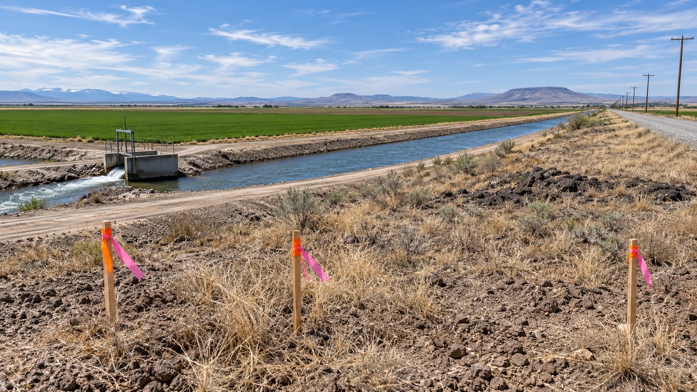
- The canal is the one nobody checks. Twin Falls Canal Company publishes right of way widths of 50 feet on main canals, 30 feet on major laterals, and 15 feet on smaller laterals, measured from the toe of the bank. Buildings, fences, and landscaping inside that are removable at your expense.
- Water rights do not always follow the dirt. Ask what the water right is, whether it is appurtenant to your specific parcel, and who delivers it.
- Outside city limits you are responsible for your own well and septic, and the septic feasibility of the ground determines where the house can sit.
- Power is not free. A long line extension is a real five-figure item, and the only number that counts is the one the utility puts in writing.
- In the Agricultural Zone, the county code requires agricultural land to be not less than 40 acres, plus or minus 5 percent.
- The soil, the frost line, and the design wind and snow loads apply to everyone here and they shape the foundation before you draw a plan.
Nobody needs all of this to be true before they buy. You just need to know which ones you are accepting. Here is the list, in the order it actually matters.
Why this post exists
The most common call we get starts with "we just closed on five acres." The second most common starts with "we closed on five acres and now we have a problem."
The problem is almost never the house. It is the lot. Access, water, power, septic, and the canal are all decided by the parcel, not by the plan, and by the time someone calls a builder the parcel is already bought.
This is not an argument for hiring us before you buy. It is an argument for asking seven or eight questions before you make an offer, most of which you can answer yourself with a phone call. We would rather you walk away from a bad parcel than build on it.
1. Access: can you legally get to it
Start here, because nothing else matters if the answer is no.
Touching a road is not the same as having legal access to it. A parcel can front a county road and still need a permitted approach before you can build a driveway, and the agency that issues that permit depends on who owns the road.
- County roads outside city limits are generally handled by a highway district. In this area that is most often the Twin Falls Highway District, and their district map is the fastest way to confirm whether your parcel falls inside it.
- State highways, including US 93 and US 30, are the Idaho Transportation Department's. An approach onto a state highway is a different and generally more involved process.
- City streets are the city's, if the parcel is inside or being annexed into one.
Then the harder question: if the parcel does not touch a public road, what is the access? A recorded easement across a neighbor's ground is real property and should appear in the title work. A handshake, a two track that has always been there, and "the previous owner never had a problem" are not access.
What to do: confirm which agency controls the road, confirm an approach can be permitted where you want it, and confirm any easement is recorded and in the title commitment. A sight distance problem at the only buildable approach location can kill a parcel.
2. The canal, which is the one nobody checks
This is irrigation country. Canals and laterals run through an enormous amount of otherwise ordinary looking ground in this valley, and the rules around them are stricter than almost anyone buying their first acreage expects.
Twin Falls Canal Company publishes its right of way widths: 50 feet on main canals, 30 feet on major laterals, and 15 feet or a proportionate width on smaller laterals, all measured from the toe of the bank. The company states plainly that a right of way "is only for operation and maintenance of the canal system," that rights of way must be "accessible without obstructions to employees, equipment, and agents," and that banks "must be free of all impediments including fences, sprinklers, and equipment." Trees are not permitted on the right of way, and volunteer trees are programmed for removal.
The company's developer guidance goes further, stating the legal right "to remove anything that blocks the easement," a list that explicitly includes buildings, parking areas, fences, and landscaping. Written permission is required before a ditch, canal, lateral, drain, or buried conduit is changed or piped.
This is not just company policy. Idaho Code backs it. Section 42-1102 establishes the right to enter land for "accessing, inspecting, operating, cleaning, maintaining, and repairing," prohibits encroachments onto the right of way without written permission, and provides that unauthorized encroachments are removed at the expense of whoever caused them.
Read that last part again. Not at the canal company's expense. At yours.
What to do: find out whether a canal, lateral, or drain crosses or borders the parcel, measure where the right of way actually falls, and treat that strip as unbuildable until the canal company says otherwise in writing. On a narrow parcel, a 50 foot right of way can move the house, the shop, the septic, and the driveway all at once.
3. Water rights do not always follow the dirt
A separate question from the canal, and one that catches people who assume irrigated ground stays irrigated.
Water rights in Idaho are property, administered by the Idaho Department of Water Resources, and they are generally appurtenant to specific land. When a larger farm gets split into parcels, what happens to the water right depends on how the split was handled. The right may have stayed with the remainder. It may have been divided. Delivery to your particular corner may or may not be physically possible even if a right exists on paper.
The practical questions are simple even if the law is not:
- Is there a water right appurtenant to this exact parcel, and what is the record?
- Who delivers the water, a canal company or an irrigation district, and are the assessments current?
- Can it physically be delivered to this parcel, or does delivery depend on crossing someone else's ground?
- If I am not farming it, am I still paying assessments on it?
What to do: ask the seller for the water right documentation in writing, verify it against IDWR's records rather than the listing, and call the delivery entity. If buying irrigated ground is part of why you want the parcel, this is not a detail to sort out after closing. We will cover water rights and delivery in more depth in a dedicated post.
4. Water and sewer, which outside city limits means well and septic
If the parcel is outside city limits and not served by a municipal system, you are building your own utilities.
The septic system is the one that constrains the house. Soil conditions, groundwater, and separation distances determine where a drainfield can go, and the drainfield location in turn constrains where the house, the well, and the driveway can go. On a small or awkwardly shaped parcel, septic feasibility can decide the entire site plan.
What to do: treat septic feasibility as a condition of purchase, not a post-closing discovery. We covered the health district process, the permits, and the sequencing in detail in a separate guide, and the short version is that this gets evaluated before you design, not after.
5. Power, and the number nobody wants to hear
Utilities get assumed. They should get quoted.
A parcel a long way from existing distribution needs a line extension, and line extensions are priced per foot by the utility based on their own engineering. Terrain, whether the run is overhead or underground, road and canal crossings, and how many other customers the line might serve all move the number. Three phase power, if a shop needs it, is a different conversation again.
We are not going to publish a cost range for this, because an honest range would be so wide it would be useless and a narrow one would be a guess. What we will tell you is that it is routinely a five figure line item on rural parcels and occasionally much worse, and that it is entirely knowable before you buy.
What to do: call the utility with the parcel number before you make an offer and ask for a line extension estimate in writing. Do the same for natural gas if you want it, because many rural parcels in this valley do not have it and propane is the alternative.
6. Zoning, and the 40 acre rule people trip over
What you are allowed to build, and how many dwellings you are allowed to put on a parcel, is a zoning question with a county specific answer.
One provision worth knowing before you shop: the county's zoning code states that in the Agricultural Zone, agricultural land "must contain not less than forty (40) acres (plus or minus five (5) percent) including canal and railroad rights of way." People see inexpensive ag ground and assume it is a building lot. Sometimes it is. Sometimes the parcel size and zone are telling you something about what the county expects to happen there.
Setbacks and minimum lot areas vary by zone district, and we are deliberately not publishing a setback table here, because the number that matters is the one for your parcel's specific zone and a wrong number in a blog post is worse than no number. Twin Falls County Community Development Services will tell you the zone and the dimensional standards for a specific parcel, and that call takes a few minutes.
What to do: get the zone designation for the exact parcel, in writing, along with the setbacks, minimum lot area, and whether what you want to build is a permitted use. If you are planning a shop, an ADU, or anything that is not a single house, ask about that specifically.
7. The ground itself
Two issues, and they are different.
Basalt. This is volcanic country, and rock sits at wildly variable depth. It can be eight feet down on one corner of a parcel and eighteen inches down forty feet away. Rock drives excavation cost, it decides whether a basement is reasonable, and it is the single most common source of site work overruns here. No builder can quote excavation accurately from a plan and a photo, and one who does is guessing.
Bearing capacity. Twin Falls County publishes a maximum presumptive soil bearing value of 1,500 psf in its design criteria. That is the assumption your footings get designed to absent a soils report. Soft spots, fill, and old farm infrastructure can all require something other than the assumption.
What to do: on any parcel where you intend to build a basement or where the price is tight enough that a surprise would hurt, consider test pits before closing or make them a contingency. A few hours of excavator time is cheap compared to discovering rock after you own it.
8. Floodplain
Less universal than the other items, but decisive where it applies.
If the parcel is in a mapped special flood hazard area, you are into floodplain development permitting, elevation requirements, and flood insurance, all of which change the cost and sometimes the feasibility of the build. FEMA's Flood Map Service Center is where the mapping lives, Idaho's floodplain management program sits with IDWR, and the permit itself comes from the local floodplain administrator.
What to do: check the flood mapping for the parcel before you buy. It is free and it takes minutes.
9. The things that are true everywhere here
These do not vary by parcel, but they shape your budget and they surprise people coming from other states.
Twin Falls County's published design criteria include a 115 mph design wind speed as a 3 second gust with exposure coefficient C, a 30 psf ground snow load, a 24 inch frost depth, a 0 degree Fahrenheit winter design temperature, and a severe weathering rating. Those drive footing depth, roof framing, connector hardware, and the thermal envelope.
We wrote about what the wind number means on an open lot in a separate post, and the short version is that exposure category matters more than most people expect.
What this looks like in practice
The sequence we would follow on any parcel:
- Confirm legal access and which agency permits the approach.
- Locate any canal, lateral, or drain and map the right of way as unbuildable.
- Check the flood mapping. Free, fast, occasionally decisive.
- Get the zone designation and dimensional standards for the exact parcel.
- Evaluate septic feasibility, because it constrains the house location.
- Get a written line extension estimate from the power utility.
- Verify water rights if irrigated ground matters to you.
- Assess the ground, with test pits if a basement is in the plan.
Most of that is phone calls and public records. None of it requires owning the parcel first.
What to ask before you make an offer
- Who controls the road, and can an approach be permitted where I need one?
- Is access recorded, or is it historical use?
- Does a canal, lateral, or drain cross or border this parcel, and where does the right of way fall?
- What zone is it, and what are the setbacks and minimum lot area?
- Has septic feasibility been evaluated, and where would a drainfield go?
- How far is the nearest power, and what has the utility quoted for an extension?
- Is there a water right appurtenant to this parcel, and who delivers it?
- Is any part of the parcel in a mapped flood hazard area?
If the seller or the listing agent cannot answer these, that is not a dealbreaker. It just means the answers are yours to find before you commit.
Looking at a parcel in the Magic Valley?
We build custom homes, additions, ADUs, shops, and remodels across Twin Falls, Jerome, Kimberly, Buhl, Filer, Burley, Rupert, and unincorporated Twin Falls County.
We will walk a parcel with you before you buy it and tell you what we see, including the things that would make us walk away. We would rather spend an hour on a lot you do not end up buying than build on one that was wrong from the start.
We are a registered Idaho contractor, RCE-65510, insured and warrantied.
Tell us about your project → or call (208) 731-1729
We are builders, not attorneys, title officers, surveyors, or water rights specialists. Easements, water rights, and access are legal questions, and the sources linked above are the authorities. Verify anything here against the agency or company that controls it for your specific parcel.
Frequently asked questions
What is the first thing to check on a rural parcel? Legal access. Confirm which agency controls the road, that an approach can be permitted where you need one, and that any access across someone else's land is recorded rather than historical use.
How close can I build to a canal or lateral? Not inside the right of way. Twin Falls Canal Company publishes widths of 50 feet for main canals, 30 feet for major laterals, and 15 feet or a proportionate width for smaller laterals, measured from the toe of the bank. Confirm the specific right of way for your parcel with the company in writing.
What happens if something is already built inside a canal right of way? Idaho Code section 42-1102 provides that unauthorized encroachments are removed at the expense of the person who caused or permitted them. The canal company's own materials list buildings, parking areas, fences, and landscaping among what it can remove.
Do water rights come with the land? Not automatically in the way most buyers assume. Water rights are appurtenant to specific land, and how a right was handled when a larger parcel was split determines what, if anything, attaches to yours. Verify it against IDWR records rather than the listing.
Can I build on agricultural ground? It depends on the zone and the parcel. The county's zoning code states that in the Agricultural Zone, agricultural land must contain not less than 40 acres, plus or minus 5 percent, including canal and railroad rights of way. Get the zone designation and the dimensional standards for your exact parcel from Twin Falls County Community Development Services.
What are the setbacks in Twin Falls County? They vary by zone district, which is why we are not publishing a table. Ask the county for the standards that apply to your parcel's specific zone.
How much does it cost to run power to a rural parcel? It depends on distance, terrain, crossings, and whether the run is overhead or underground, and the only number worth having is a written estimate from the utility for your specific parcel. It is commonly a five figure item on rural ground.
Should I test for rock before I buy? If a basement is in the plan or the budget is tight, yes. Basalt depth varies dramatically across short distances in this valley, and excavation surprises are the most common site work overrun here. Test pits before closing cost a fraction of what the surprise does.
What design loads apply here? Twin Falls County publishes a 115 mph design wind speed at exposure C, a 30 psf ground snow load, a 24 inch frost depth, and a 0 degree Fahrenheit winter design temperature. Those apply regardless of which parcel you buy and they shape the foundation and framing.
Can I check flood mapping myself? Yes. FEMA's Flood Map Service Center carries the mapping, and Idaho's floodplain management program sits with IDWR. The development permit itself comes from the local floodplain administrator.
Do I need a builder before I buy the land? No, but it helps to have one walk it. Most of what is on this list you can verify yourself with public records and phone calls. The value of a builder on the parcel is spotting the things that are not on any list.